Even that seems like an understatement!!!! The Valley floor is already higher than Kosciusko (2228m) at 2800m, and that was our starting point.
Last week, Lex and I took a local bus out to Ollantaytambo - an Incan town on the western end of the Sacred Valley. So for the small sum of S/20 we were on our way for a 2 hour bus ride ... and an adventure in store. We had done a little research - checked out some possible accommodation places and possible walks - but nothing booked - after all, this is not the high season!!!
We decided on an inexpensive hostal - mostly because the operator also runs some adventure tours, and would be able to provide good information for us. We were right - information on walks was terrific!! Most of the major Inca sites can only be accessed with the Tourist Ticket - one ticket which for all, but it only lasts for 5 days. Impossible the way we want to amble around the country side, and we've been to most before. Just above Ollantaytambo, there is a huge site generally known as the Fortress. This wasn't on out to do list for this trip - but there are so many places and sites all around the valley. There was plenty to see.

Inca Fortress is the backdrop for Ollantaytambo. Our hostal was on the right and looked up towards ruins on the opposite mountains.

LARGE groups of tourists can be seen on the terraces each day

View from our room in the mornings - cloud on the top of the mountains, but some of the ruins still visible. We climbed up to these!!
Day 1: Just an afternoon walk up to Pinkuylluna Ruins - ones we could see from our room. 2.5km, steep path. Difficulty: Moderate Elevation: 3050m
And it certainly was steep. Have seen these ruins on previous trips but didn't realise it was possible to get up there. It's all UP and anything Up at this altitude causes shortness of breath - so we have lots of vista stops to enjoy the view. It was amazing!!
Great sense of achievement for me - definitely NOT a brave climber, but there was little wind. I was grateful for that.
Day 2 - Pumamaca Ruins 4-6hours, 13km, Difficulty: Moderate Elevation 3425m
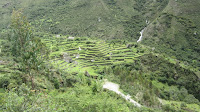
This was certainly a l-o-n-g trek (took us just over 6 hours) with some quite steep sections - but it was truly amazing. The Pumamarca ruins are Pre-Inca, but there is so much more to see along the way. We passed by many sections of terracing - most impressive was a whole hillside of terraces - apparently over 100. There is just so much around - cannot imagine how many people, or how long it would have taken to construct these - or how much work it would have been to farm them as well. Some appear to be farmed now, and others - maybe they are just maintaining them - but many are not maintained. Sooooo much work.
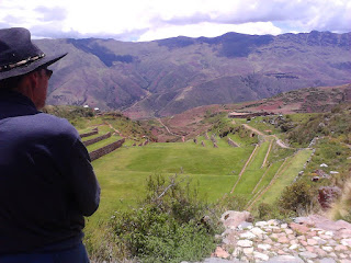
Once we reached this spot, we could see a table set with red table cloth - someone was coming way up here for lunch. Wasn't us. We could see the ruins above us from here but we still had about half hour climb up abut a dozen large terraces!!!
No entrance fee here - and we were able to wander around, and have a small picnic. So high!!!
We'd been given tips by another group of hikers - make your way down the mountain to the road and follow it back to Ollantayatambo. It was a scramble - through fields, between houses, cutting across to the road as it zig-zagged its way down to the valley. From there we followed the road back to town - going DOWN all the way. The road followed the path of the river which roared at times as it also dropped, sometimes steeply, down to the the town as well.
This is the mountain of terraces - people were working on some of the lower ones.
Another aspect of Inca engineering that amazes us is the way they have channelled water around the country. There are stone water channels all over the mountains and through the town as well. It is really spectacular.
Late lunch - trout. Delicious.
Day 3: NO walking - Hitched a ride with a group planning to ride bikes down from a high pass - Abra Malaga. 4400m. $25 for the 2 of us - BEST $25 ever - Simply stunning experience
As we drove up around and up the mountains, KB gave us a running commentary about various ruins and terraces we passed along the way. We'd been travelling upwards for quite some time, and he said "We're about a third of the way up."
The scenery was stunning, and got better with every turn. The road was quite new and in excellent condition - what a feat to put that road in that environment - up over the Andes.
As we got close to the top, small children appeared along the side of the road, with hands out. We stopped and they were given some bread - KB explaining that they'd made a conscious decision to give food rather than money.
Close to the top, KB gave riders a safety talk - stressing the dangers and making me feel very comfortable that we were riding back down inside the vehicle .... and not on a bike.
We got to the top of the pass - way up in the clouds, and stopped for a short time, but the ride was to start a little lower, out of the clouds. Down the other side of the mountains is the way to the jungle - and a back way to Machu Picchu.
We could see dwellings and cultivation - even at this elevation. It must be a hard lifestyle, with very few of the creature comforts we are so accustomed to.
Bikes were unloaded, riders prepared with all the necessary safety gear. For us it was an opportunity to look around. We were way, way UP!!! What a privilege to be there.
Along the way down, we followed the riders and stopped a couple of times to enjoy the scenery. Looking down (and up) at the road we had travelled was an amazing feeling.
After such a spectacular road down the mountain, it's unbelievable to see that the last few kilometres back into Ollantaytambo is rough, single lane dirt road. Unbelievable!!! And even more so is the fact that ALL traffic from the mountain goes right past the ruins and through the ancient Inca township. Along this dirt section of the road, you can see large stones that are believed to have once been destined for nearby Inca structures, but had been left abandoned when the empire fell. Such stones can be seen in the township as well.
This trip was a highlight of our week!!!! Maybe we can do it again - and hope for similar, mostly clear weather!!!
Day 4: Walk ( UP of course) to the quarries where Incas got huge stones for their constructions. 4.5-6.5 hours Distance 14.5km Elevation 3500m Difficulty: Moderate
It wasn't a hard walk - but it was UP, and very long, especially since we did a couple of kms extra before we got to the track - so our walk was about 7 hours that day.

STUFFED!!!
You can just see the track .... end of my finger, up and away into the distance.
Eventually we came to the first (and smaller section) of the quarries. There are many large rocks which we assume have been partially shaped for construction sites.
Not sure what these structures were - Lex suggested 'tool sheds' - they had Inca tools in them .... rocks!!
We wandered further up the slope, but the path was less defined, so headed back the way we had come. Spotted some beautiful humming birds in a corn field along the way.
Finished off the day with drinks in an English pub, and choclo con queso (corn with cheese) from a lady in the plaza. S/2 (2 soles)
Day 5. Time for a shorter walk. Intiwatana Ruins - on the hilside above the Ollantaytambo Fortress. 1.5hrs. 2.5km Elevation: 3050m Difficulty: Moderate- Difficult
Suffice to say it was DIFFICULT - steep incline with loose rocks - just above the rough, dirt one-lane road.
I was NOT a pretty sight!!!
We opted not to continue with this walk - headed back to town and caught a taxi back to Cusco.
What a brilliant week - and there's still more to do and see, so we'll be back!!
Lots more pictures of this trip in the Sacred Valley slideshow - link on right of this blog.


